
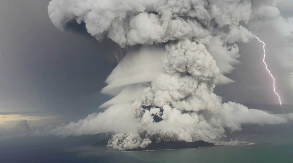
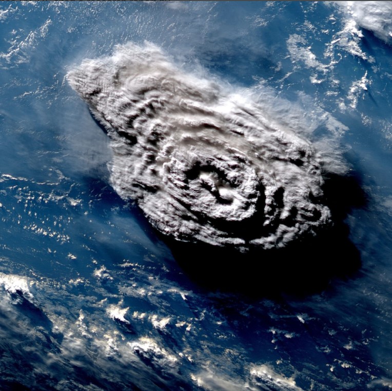
 HUNGA TONGA – HUNGA HA'APAI was an uninhabited volcanic twin island of Tonga in the South Pacific Ocean that existed between 2009 and 2022. The two islands, Hunga Tonga and Hunga Ha'apai, merged into one island during an eruption in 2009. Twin Island was obliterated in the violent eruption on January 15, seen here. Many volcanic eruptions are followed by powerful lightning discharges and over 200,000 lightning flashes were recorded in the gas cloud (one can be seen th in picture). The reasons behind this phenomenon are debated. Some believe that it is about static electricity between spewed particles, others that the earth and everything on it, including humans, are more electromagnetically influenced/controlled than today's science wants to claim. Still image: Tonga Geological Services
Volcanic eruption in Tonga will contribute to global cooling
When the underwater volcano in the island nation of Tonga in the South Sea had its explosion-like eruption on January 15, 2022, a massive pressure wave, more powerful than the largest atomic bomb, spread through both the Earth's oceans and atmosphere. The catastrophic event created a record-high ash and gas cloud that continues to spread over the earth.
Published: January 5, 2023, 8:11 am
Much worse is that it has dramatically reduced solar radiation over large parts of the earth and caused the temperature in the atmosphere to drop drastically, which affects agriculture in the southern hemisphere. A selection of available new data reveal that the authorities tried to hide the extent of the disaster. There is a historical connection that is relevant too.
HUNGA TONGA – HUNGA HA’APAI – Background info
On December 20, 2021, the underwater volcano Hunga Tonga-Hunga Ha’apai, the name of the twin islands where it is located, began spewing ash into the South Pacific. Four weeks later, on January 15, 2022, the eruption reached a gigantic and powerful climax that generated a very loud supersonic boom. It was heard all over the Polynesian archipelago and as far as Alaska, 1 000 miles away. The eruption was more than 4 000 times more powerful than the 15 kiloton atomic bomb the US dropped on Hiroshima and the most powerful since at least the 1883 eruption of the Krakatoa volcano in Indonesia, which triggered a global volcanic winter.
Researchers at the British University of Sheffield released a study (Díaz et al.) on August 9th that demonstrates that the Tonga eruption corresponded to an earthquake with a magnitude of 8,4 on the Richter scale or around 61 megatons of TNT/TNT. As a comparison, the largest atomic bomb ever tested, the Soviet Tsar bomba, had an explosive power of 50-58 megatons.
“We’ve never seen anything like it,” said Luis Millán, NASA/JPL Atmospheric Aerosol Science Scientist, on the huge gas cloud.
Initially, the worst was feared for the island nation of Tonga and its around 110,000 inhabitants, when all communication with the outside world was cut off after an internet cable on the seabed was destroyed. The main island is located 65 kilometers from the underwater volcano, but the feared giant tsunami did not occur, although it caused damage in the island nation where many buildings were destroyed, at least six people were killed and several are still missing today. The tsunami did not have a high wave, but it was still powerful enough to reach with large waves of low amplitude (wave height) the coasts of everything from Russia and Japan in the north to the United States in the northeast and South America in the east, where coastal areas were flooded in several places. For example, streets were flooded in Peruvian coastal cities, where two beachgoers also drowned by a two-meter wave that is believed to have been created due to special bottom conditions there.
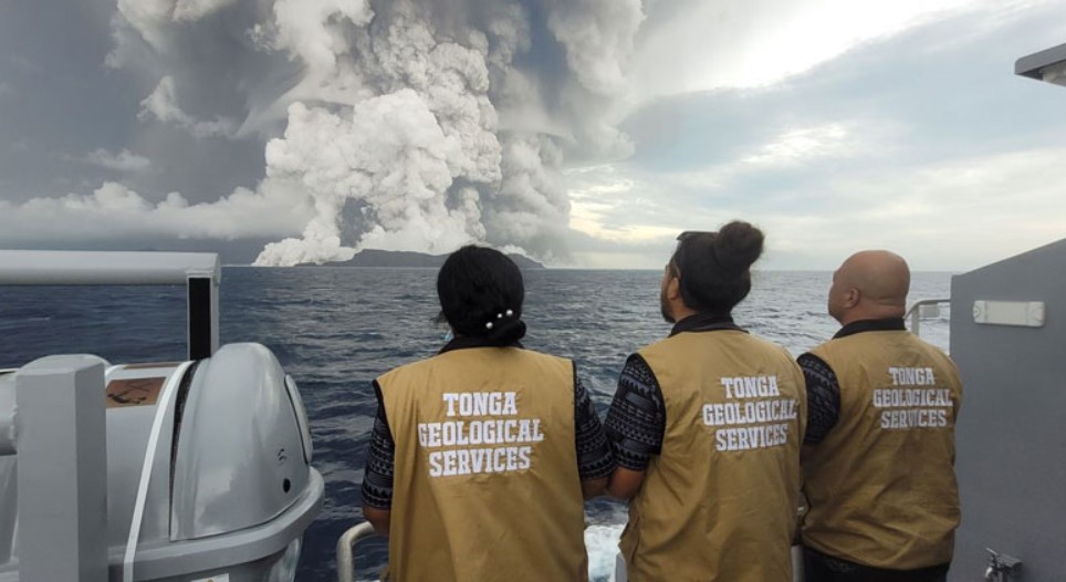
THE CATASTROPHIC Eruption on January 15 is witnessed by Tonga’s geologists, who saw parts of their island nation devastated. Photo: Tonga Geological Services
Mainstream media reported on the outbreak with a focus on the island nation of Tonga and when contact was finally established, the focus ended up on details such as aid work being hindered by Corona restrictions, as Tonga was claimed to have just had its first known Corona case. The talked-about high tsunami wave never came and “the ash cloud was not that special even though it initially looked spectacular”, was the anticlimactic picture that was painted in many. In just a few days, the volcanic eruption almost completely disappeared from mainstream media reporting. However, it would later turn out that the disparaging information was not true at all.
57 kilometer high plume
In January and February, Swedish weekly Nya Tider had contact with well-initiated sources who, already in the first weeks after the eruption, claimed that what happened was much worse than it was portrayed and that it would have serious consequences for not only the southern hemisphere, but the entire earth’s climate. They went so far as to say that it was deliberately blacked out by the establishment and its media and that “scientists felt pressure not to be alarmist”. But since they wanted to remain anonymous and could not present concrete data, we then chose not to report on it.
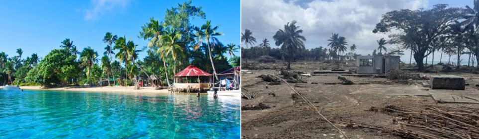
SÖDERHAVSDRÖM (tv) turned into a shattered nightmare (th) on 15 January this year. The Kingdom of Tonga is an independent state and archipelago located in the South Pacific Ocean, consisting of 176 scattered islands in an area of over 700,000 km². 52 of the islands are inhabited. The Kingdom stretches over a distance of about 800 km in a north-south line and is about a third of the distance from New Zealand to Hawaii. Tonga also became known as the “Friendly Islands” due to the friendly reception that British explorer James Cook received on his first visit there in 1773. Photos: Pangaimotu Island Resort & Consulate of the Kingdom of Tonga
Now, however, much of what our sources said earlier this year has come to light as a number of system media articles suddenly appeared at the beginning of November. Dozens of major mainstream media outlets suddenly went out with the information at the same time. For example, the British Daily Mail had an article on November 3 with the headline “Tonga’s underwater volcanic eruption produced the highest plume ever documented, reaching a height of 187 000 feet [57 kilometers], study reveals”.

We have never seen such a high cloud of any type before. – Simon Proud, Meteorological and Satellite Data Analysis Expert at the University of Oxford, Department of Physics. Photo: University of Oxford
The study in question was published the same day in the American scientific magazine Science and was carried out by researchers at the UK’s Oxford University and RAL Space, who used three geostationary weather satellites to precisely measure the height of the enormous plume. The Rutherford Appleton Laboratory (RAL) is one of the most important English public research institutes working in particle physics, space science, astronomy, computer science, biology, medicine and chemistry. RAL was founded in 1957 and is affiliated with the British authority Science and Technology Facilities Council (STFC). RAL Space focuses on everything related to space, from 60 years of participation in several space programs to analyzes of measurement results from satellites.
“For me, what was impressive is how fast the outbreak was. It went from nothing to a 57 kilometer high cloud in just 30 minutes. I can’t imagine what it must have been like to see from the ground,” said the study’s lead author Simon Proud in the Daily Mail.
The Tonga eruption thus beat the record holder Pinatubo, a very active stratovolcano in the Philippines, which when it erupted in 1991 caused a plume that was 40 kilometers high. Research manager Proud says that they used a new way to measure the height more precisely called the parallax method, which is only “possible now that we have good satellite coverage”. He further explains that “it would not have been possible a decade ago”.
New measuring technology provides precise results
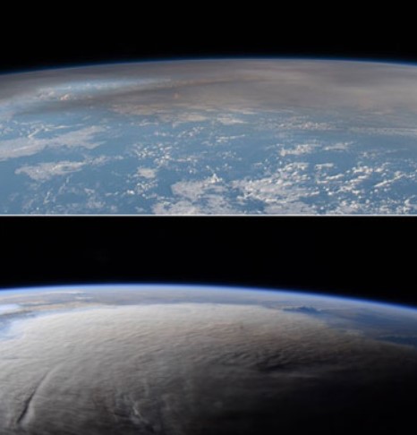
THE HUGE ASH CLOUD from the Tonga eruption stretches over large parts of the earth after just one day. These photos were taken from the International Space Station ISS on January 16, the day after the massive eruption. Despite countless satellites and the fact that the ISS passes over the area every 90 minutes – day in and day out – only a handful of photos and only from the first 24 hours are available to the public. Billionaire Bill Gates last year launched plans to block the sun by spreading dust in the atmosphere to “counteract global warming” (see NyT v.15/2021), but this is on a completely different scale. Photo: NASA
Previously, the temperature at the top of the plume was measured using infrared sensors on satellites and then compared the results with known standard temperatures at different heights. This can be done because previous ash and gas clouds have only extended into the troposphere, the first layer of the atmosphere, where temperature decreases with height. But the gas cloud from Hunga Tonga went all the way up into the third layer of the atmosphere, the mesosphere. Because the ozone layer absorbs ultraviolet radiation, the temperature in the stratosphere and mesosphere, the second and third layers, increases with altitude. So opposite to the troposphere, the atmospheric layer below.
To be able to measure the height of the gas cloud, Proud’s team developed another technique that uses the “parallax effect”, i.e. the distance difference to an object seen along at least two different lines of sight. It makes it possible to calculate the distance between the observers and the object. This measurement technique is not new in itself, but has not been used to measure the height of ash and gas clouds before. It was made possible by the fact that the location of the Tonga volcano is covered by three weather satellites, all at an altitude of just under 36 000 kilometers.
These are American GOES-17, Japanese Himawari-8 and South Korean GeokompSat-2A. Images taken by these satellites, with a known position, were then used to measure the height of the plume. In addition, they recorded images every ten minutes, which means the researchers were able to document changes in the cloud’s height, spread and trajectory.
Overall, this means that the measured record height is not estimated, or as with climate models pure data-generated guesses, but precisely measured. When the plume’s record height, enormous scope and subsequent spread over the earth became clear to the scientists, many also realized how serious the eruption in January was, is and will be for the earth’s climate. It was so alarming that in the spring they began to divulge figures regarding its consequences for the public.
45 times more than thought
What initially misled the public was that the ash cloud was not historically large, but in reality the eruption and its gas cloud, counting ash and water vapor combined, was the largest ever known in modern history. This is even though the 400 000 tons of sulfur dioxide, one of several gases Tonga released into the atmosphere, was only two percent of the amount that Pinatubo spewed in 1991.
According to a study from November by the New Zealand government research institute National Institute of Water and Atmospheric Research (NIWA ), the water vapor equivalent to 2,6 million swimming pools of Olympic standard was thrown into the atmosphere. This is remarkable as NASA as recently as early August estimated it to be “only” 58 000 swimming pools. Before that there were even lower numbers. It indicates that the scientists see something that makes them look for an explanation as to why the cloud is so large and therefore write down the constituent substances and gases of the plume. In this case with the water vapor, the estimate was increased by 45 times in just three months.
On October 24, the science magazine EOS, which belongs to Advancing Earth and Space Science (AGU), cited a research report by Schoeberl et al. (10.1029/2022GL100248). There, too, it appears that the amount of water vapor was the largest ever measured during a volcanic eruption. They write that up to 150 teragrams, or 150 000 000 000 kilograms, were shot up into the Earth’s stratosphere during the eruption.
The atmosphere and the earth’s surface cool
THE HIGHEST PLUME EVER could both be seen and felt from space. The ash and gas cloud was larger than France and the shock wave made several revolutions around the Earth, while satellites were hit by hurricane force winds and electric currents in the ionosphere. The ionosphere is located in the outermost part of the Earth’s atmosphere in the altitude range of 70 – 1,000 kilometers, where the gas is partially ionized so that there are free electrons and ions. There are many satellites and the space station ISS, which orbits the Earth at an altitude of 420 kilometers. The eruption was the largest explosion ever recorded in the atmosphere by modern instrumentation, far larger than any volcanic event of the 20th century or even the largest nuclear weapons test. Photo: Simon Proud University of Oxford RAL Space, NCEO Japan Meteorological Agency
Water vapor made up a large part of the huge plume of ash and gas that rose to a height of 57 kilometers. Several months after the eruption, it could be noted that greatly elevated values of water vapor and sulfur-rich aerosol particles still remained in the stratosphere. The researchers base this on measurements made between January 15 and July 1 with NASA’s instruments on board the Aura satellite. The data show that as early as February, the water vapor and sulfur-rich aerosol particles separated into two distinct but overlapping air layers and spread until the end of June, as long as the measurement results were given. We therefore do not know what happened afterwards.
The researchers then write that “a surprising result” was that the gas cloud at a certain height, in the middle layers of the stratosphere, “remained in the southern hemisphere for 5.5 months, with very little material moving north of the equator.” That it did not spread as expected, even if it only concerned one of several altitude layers, further worsened the situation for agriculture in the affected areas. The researchers concluded that the unusually powerful eruption, which created such a high plume, is the reason for the enormous amount of water vapor that now remains in the stratosphere – something never seen before.
Nya Tider’s sources point out here that while system media and “research” will try to point to global warming, as water vapor is said to be a “greenhouse gas”, the actual belief is something completely different. An example of such misinformation is from the New York Times, which on September 22 wrote that the eruption “is expected to increase warming for several years until the gas dissipates”.
But the reality is quite different. The gigantic cloud of gas and ash – which has spread over large parts of the earth – blocks solar penetration and lowers the temperature, both on the earth’s surface and in the atmosphere. Scientists have been surprised by the cooling in the stratosphere.
Our sources’ claim is also corroborated by EOS/AGU who – for other researchers – write: “The data also revealed the development of an anomalous temperature drop in the mid-stratosphere of 3 to 4 degrees Kelvin through March and April, which appears to have been caused by the infrared cooling effects of the regurgitated water vapor.”
This corresponds to a reduced temperature of 3 to 4 degrees Celsius. We thus have both cooling in the atmosphere and, due to the reduced solar radiation, also on the ground surface. The consequent colder weather in itself also results in a shorter growing season and could threaten crops with frost damage. This evidently goes against the mainstream “global warming” narrative.
Photos and numbers are hidden
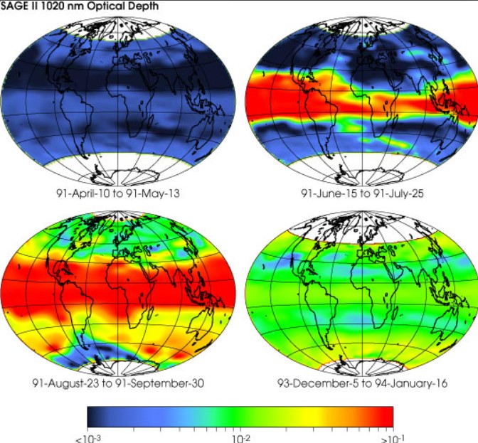
THE EFFECTS OF PINATUBO. The eruption in the Philippines on June 15, 1991 threw 20 million tons of sulfur dioxide and ash into the stratosphere and had noticeable consequences for weather and agriculture worldwide. Here we see the optical depth of atmospheric aerosol particles, which very simply translates to how much sunlight is let through. We see here four time periods, indicated under the respective globe/map. Blue TV at the bottom of the scale means few particles. The initial dispersion of the ash cloud in the atmosphere is visible through the red color, th on the scale, which means many particles and thus little transparency/light penetration. It very seriously affects agricultural harvests and volcanic eruptions have historically caused years of crop failure far from the eruption area. We can see that the negative effects were greater 15 months after the outbreak than before. Three years later, almost the entire Earth was still affected, although not as much. This gives an indication of what to expect from the Tonga eruption this year. Click for larger image. Source & image: NASA
For reasons of space, we now choose to summarize our sources’ view of and conclusions about the outbreak and all available data, from which we have presented only a small selection above. However, the New York Times admitted something that even our sources warn about, that the gas cloud will affect us for a long time. But not that it will lead to a cooler climate on Earth.
By studying Pinatubo’s much smaller eruption in 1991, we can create a picture of what to expect. According to the study “The Atmospheric Impact of the 1991 Mount Pinatubo Eruption” by Self et al. published by the United States Geological Survey (USGS), the Earth’s average temperature dropped by 0,5 to 0,7 degrees Celsius as a result of the eruption in the Philippines in 1991. Two years later, the cooling effect was stated to be “as large as -0.4 °C”. Agriculture was very negatively affected by the Pinatubo eruption, but the Tonga eruption earlier this year was significantly larger – and thus has significantly worse consequences.
It is only when we see pictures taken from space that we get a true idea of how big the natural disaster was and is. In just one day, the ash cloud covered large parts of the earth, which was visible from, among others, the International Space Station ISS. But even though the ISS passes over the area every 1,5 hours, 16 times a day, there are only images from the first day. Our sources state that those taken later have been classified, as they show such a large ash and gas coverage that the scale of the disaster would be obvious to all. In the same vein, the news also disappeared from the world’s mainstream media.
Measurement data has also disappeared, and not least those showing the spread of the ash and gas cloud across latitude, north and south on the earth seen from the Tonga eruption. All authorities and organizations seem to have stopped reporting between March 1 and the end of June. One of the last to report was the New Zealand government research institute NIWA, which it did at the end of May (see chart).
Dramatically reduced solar radiation
We can state that the effects of the Tonga eruption – before the data was blacked out – are very serious. It affects all important growing areas in the southern hemisphere. Not only is it a very large area of spread for the gas and dust cloud, which has also crossed the equator and made it north to at least the Tropic of Cancer, but it has greatly reduced solar radiation to Earth since the eruption in January.
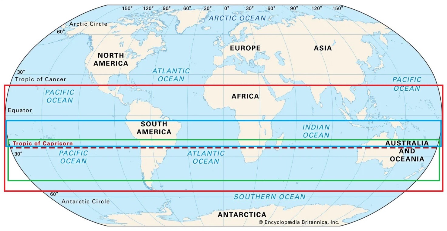
AREA AFFECTED by the Tonga eruption dust cloud in the Southern Hemisphere in red frame. This is based on the latest data from NIWA at the end of May, when reporting ceased. Since then it has expanded further. The solar radiation has decreased by a dramatic 1-2 W/m2 within the blue frame. All Southern Hemisphere agriculture of importance, within the green framework, has been very negatively affected. This applies to the important growing areas of southern Brazil, Paraguay, Uruguay and Argentina in South America, all of southern Africa, Australia and New Zealand. It has already started to be felt in abnormally cold weather, including snow at the end of November (their May), few and “weak” (low W/m2) hours of sunshine and thus poor harvests. Map: Encyclopaedia Britannica, Markings: NyT
Solar radiation or insolation is a measure of incident solar radiation on the ground, i.e. the amount of solar energy on a given surface, and is expressed in Watts (power) per square meter (W/m²). The solar radiation has decreased over large areas by a dramatic 1-2 W/m2, which historically – including during the Little Ice Age (1430-1850) and its many volcanic eruptions – led to catastrophic consequences.
For example, during previous solar minimums, periods when the sun has unusually low activity, solar radiation decreased when it was at its worst by 1 to just over 1.5 W/m2. According to NASA, we entered a new solar minimum in December 2019, shortly before the Covid-19 pandemic was declared, and this solar cycle (number 25) will continue for about eleven years, until 2030.
For example, during the Maunder Minimum cold period (1645-1715), when the Great Belt froze so that Karl X Gustav could surprisingly march across the strait towards Copenhagen in 1658, the radiation dropped by around 1 W/m2. Combined with several volcanic eruptions, which become more frequent in connection with a solar minimum, it led to several years of crop failure and mass collapse. It has been estimated that a quarter of the world’s population died during that time. It was the last Grand Solar Minimum that hit humanity.
That the solar radiation after the Tonga eruption really decreased by as much as 1-2 W/m2 can be established based on the latest available figures from the end of February (Zhu et al. published in Nature on October 28, 2022). After this, they stopped reporting the explosive data.
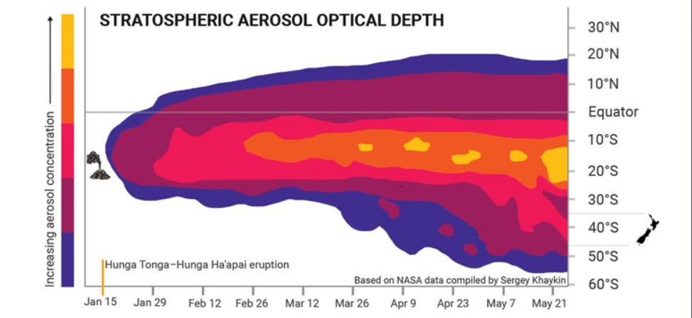
THE SPREAD OVER LATITUDE. This graph shows how the optical depth of atmospheric aerosol particles spread from Tonga’s latitude 20.57°S (the volcano marked tv on the time scale, bottom) between the eruption on 15 January until the end of May, when reporting ceased. The concentration of particles is indicated on the color scale (farthest two). We can see that already a week after the eruption the gas cloud has passed the equator (grey line). In April, it reached latitude 20°N, which cuts through, for example, Hawaii and Mexico. In May it reached 55°S, which runs at the southern tip of South America. In New Zealand (within gray lines on the th latitude scale at 40°N) the particles from the volcanic eruption have created unusually beautiful sunsets with red-orange shimmering evening redness. Source: NASA, Chart: NIWA
By studying the consequences of Pinatubo’s eruption in 1991, we can assume that the spread of the Tonga cloud in the atmosphere will now affect solar radiation over mainly the southern hemisphere until at least April-May next year. It coincides with the current growing season in the Southern Hemisphere, where it is now summer.
Even after the spring of 2023, we can count on continued noticeable effects on temperature and agriculture at least into 2025.
All rights reserved. You have permission to quote freely from the articles provided that the source (www.freewestmedia.com) is given. Photos may not be used without our consent.

Consider donating to support our work
Help us to produce more articles like this. FreeWestMedia is depending on donations from our readers to keep going. With your help, we expose the mainstream fake news agenda.
Keep your language polite. Readers from many different countries visit and contribute to Free West Media and we must therefore obey the rules in, for example, Germany. Illegal content will be deleted.
If you have been approved to post comments without preview from FWM, you are responsible for violations of any law. This means that FWM may be forced to cooperate with authorities in a possible crime investigation.
If your comments are subject to preview by FWM, please be patient. We continually review comments but depending on the time of day it can take up to several hours before your comment is reviewed.
We reserve the right to delete comments that are offensive, contain slander or foul language, or are irrelevant to the discussion.
In Focus

Sweden’s NATO membership bid goes up in smoke
StockholmAfter the burning of the Quran in Stockholm, Turkey has no intention of allowing Sweden to join NATO. Sweden's Prime Minister, on the other hand, pointed to the importance of freedom of expression. The NATO Secretary General also spoke up on the matter.
French NATO soldiers in Romania hungry, freezing, overrun by rats
CincuFrench NATO soldiers stationed at the Cincu military base in Romania bitterly complained to an investigative journalist about the terrible living conditions they suffer. They live in filthy prefabricated houses from Mali that are hardly heated, there are not enough toilets, and garbage is piling up in the camp.
War or peace? The future of Transnistria
The war is getting closer to Transnistria every day, but the region – a self-proclaimed republic with Russian backing – is still calm and life goes on as usual. However, several threats are on the horizon. Is Transnistria the first country to which war will spill over? We visited this almost forgotten part of Eastern Europe where the Soviet heritage is still visible and present.

Exclusive: Swedish politician’s Bilderberg attendance exposed through FOI
StockholmSweden's Minister of Social Affairs Lena Hallengren traveled to the US at the beginning of June to meet globalist politicians and vaccine companies, as well as to attend the Bilderberg Group meeting in Washington DC. The whole thing became an expensive trip for Swedish taxpayers. Hallengren not only chose to fly business class on all flights, but she also stayed in several different luxury hotels.
‘Fiat money needed to hide Great Reset costs’
ViennaThe failure to put the financial system on a solid footing after the financial crisis in 2008, the pandemic and sanctions due to the Ukraine war, have ensured that the cards are finally being reshuffled.

The Trogneux mystery
ParisThe First Lady of France could end the suspense of the disappearance of Jean-Michel Trogneux in the blink of an eye, by appearing in the simplest of clothes: A birth suit. Especially since the French are not overly sensitive about nudity.

At least 69 athletes collapse in one month, many dead
The reports of athletes who suddenly collapse have been increasing noticeably lately. Heart problems such as heart inflammation are often the cause – one of the known life-threatening side effects of Covid vaccines, which even the manufacturers themselves warn against.

The bat that flew away
BerlinMostly claiming the old and very sick, there has been a notable trend of promoting iatrogenic treatment (where the cure was worse than the disease) including excessive use of invasive mechanical ventilators and ineffective and expensive Big Pharma drugs like Remdesivir to treat a pandemic allegedly created by a "bat" from Wuhan in China.

Norway reclassifies Covid-19: No more dangerous than ordinary flu
OsloCovid-19 is treated in the mass media as a very dangerous disease in the face of which mass vaccination and severe restrictions for the whole society are applauded despite few deaths beyond the risk groups. But in Norway, it has now been decided to treat it like other respiratory diseases, such as influenza or the cold virus, because according to the Norwegian Institute of Public Health it is no longer more dangerous than these.

No comments.
By submitting a comment you grant Free West Media a perpetual license to reproduce your words and name/web site in attribution. Inappropriate and irrelevant comments will be removed at an admin’s discretion. Your email is used for verification purposes only, it will never be shared.